Map grid – the map of the world
The Planetary Grid System
Some of the significant features of the major grid intersections:
(1) Giza,the Great Pyramid
(3)Tyumen oil field, USSR
(4) Lake Baikal, USSR, many unique plants and animals
(9) Hudson Bay, present location of north magnetic pole
(11) northern British Isles, Maes Howe, Ring of Brodgar, Callanish
(12) Mohenjo Daro—Rama Empire culture
(13) Xian Pyramids, largest in the world
(14) southern Japan, “Dragon’s Triangle,” great seismic activity
(16) Hamakulia, nearby lies Hawaii, scene of high volcanic and earthquake activity
(17) the sophisticated canal civilization of Cibola
(18) Bimini, the site of huge “man-made” walls underwater, discovered in 1969, the date that Edgar Cayce had predicted that evidence of Atlantis would be discovered
(20) Algerian megalithic ruins
(21) megaliths at Axum, the Coptic Christian center in Ethiopia
(25) Bangkok and Ankor Wat
(26) Sarawak, Borneo, site of ancient megalithic structures
(28) Pohnpei Island, Micronesia, site of the megalithic city of Nan Madol
(35) Lima, Peru, boundary of the Nazca Plate, Pisco, the Candlestick of the Andes & the Nazca Lines
(40) Gabon, West Africa, natural atomic reactor in operation about 1.7 million yearsago
(41) Zimbabwe with its ancient mines & structures
(44) the Maralinga Atomic Test Site, which also has megalithic ruins
(47) EasterIsland and its megaliths
(62) German underground Antarctic base?
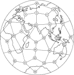
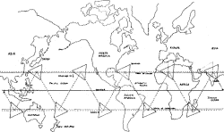
The ten “vile vortices” originally taken from Ivan T. Sanderson.
At these ten areas, theoretically, magnetic-gravitational anomalies take place. Nicholas R. Nelson, in his book, Paradox (1980, Dorrance & Co. Ardmore, Penn.), believes that these vortex areas are entrances to other dimensions.
Such “doors” to other dimensions would account for strange disapearances and mysterious vanishings.
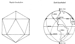
More illustrations from Paradox, Nelson sees the earth as an Icosahedron. Below is an enlargement of the Bermuda Triangle vortex area, one of the supposed “vile vortexes”.
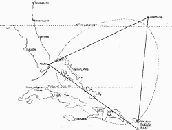

Here we see how other dimensions or parallel worlds can connect with the earth, theoretically at the ten hypothetical vortex areas of the earth.
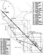
This illustration is from the book Genesis de la Cultura Andina (Genesis of the Andean Culture) by Carlos Milla Villena, published in Peru.
It shows the “grid line”-mathematical relationship of the megalithic remains of Tiahuanaco in Bolivia, with those in Cuzco, Peru and Vitcos, brief capital of the Incas in exile, as well as the point of entry into Peru that Pizarro and his conquistadors took during their conquest.
Also on the grid line is Cajamarca, where the conquistadors captured the Inca Atahualpa and so sealed the fate of the Inca Empire. Were the Incas, or perhaps an earlier culture aware of the world grid?
